
The Forgotten House of James Vassar

When I first saw the house looming behind the Sunoco at the corner of Washington St and Bain Ave in the shadow of the walkway over the Hudson, I immediately knew it predated the 20th century. Its unusually large front gable, pair of symmetrical wings, and colonnaded front porch placed it firmly within the Greek Revival Style popular in the first half of the 19th century. Yet, a cursory Google search showed the home's build date as 1920, long after the style had fallen out of favor.
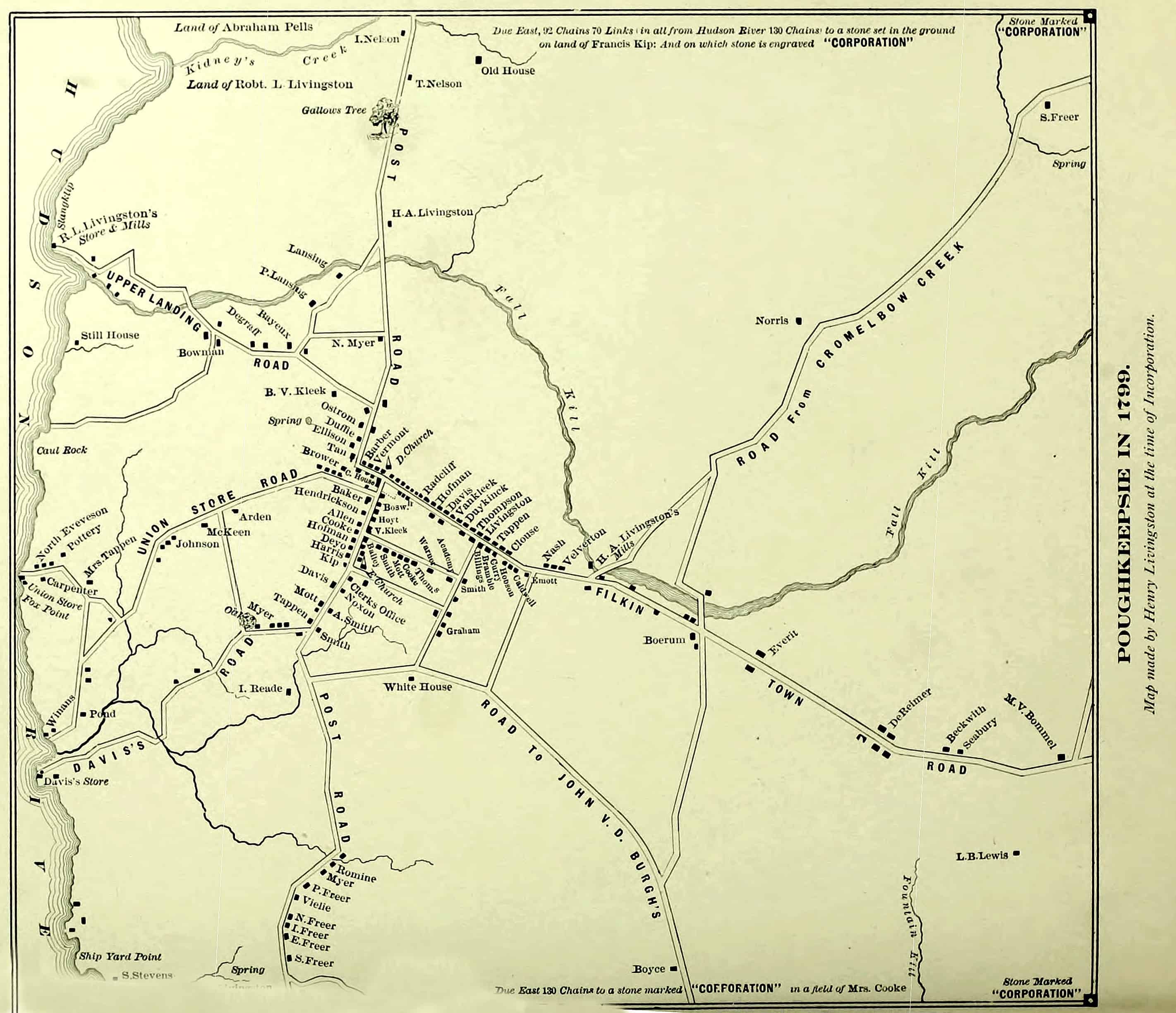
I subsequently sought to prove my theory, starting by examining the oldest map I could find of the area —a 1799 map of Poughkeepsie created by Henry Livingston at the time of the city’s incorporation. The map showed the parcel in question as undeveloped and part of a larger parcel owned by one Robert L. Livingston. This was unsurprising to me, as the survey was conducted prior to the emergence of the Greek Revival style.

Livingston, Herny, “Poughkeepsie in 1799”, 1799, Dutchess County Historical society, https://dchsny.org/wp-content/uploads/2019/08/Poughkeepsie-Map-1799-Trans-EaglHist.jpg. Accessed 14 October 2025.
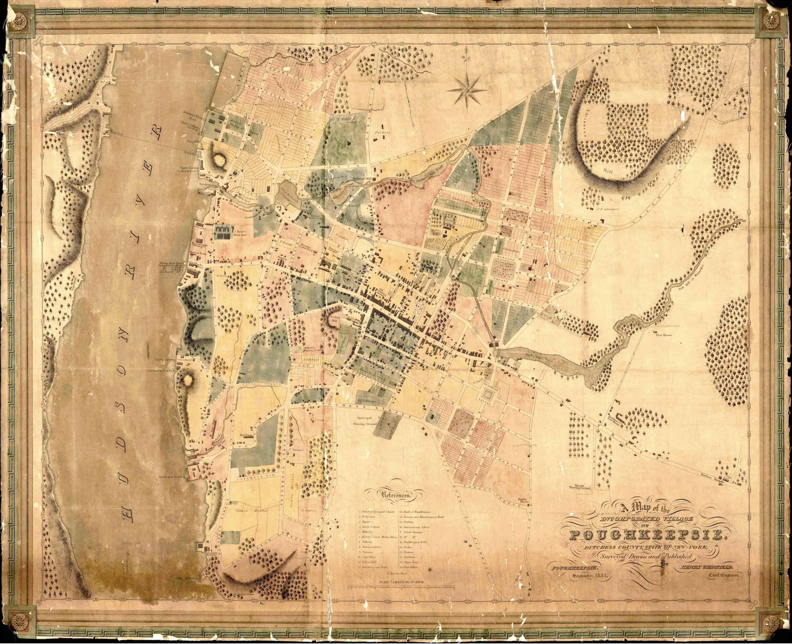
The next map I found was a 1834 work by civil engineer Henry Whitfield of the incorporated village of Poughkeepsie. Surprisingly, it showed the plan of a dwelling on the lot in question, which closely corresponded to the current structure. More shocking still, the residence in question was labeled “Vassars,” a prominent family in the city, which included Mathew Vassar, who founded my Alma Mater, Vassar College. Note the position of the Vassar property in relation to the adjacent “Parkers” parcel.

Whitfeild, Henry, “A Map of the Incorporated Village of Poughkeepsie”, September 1834, Dutchess County Historical society, https://dchsny.org/wp-contelabeled,nt/uploads/2019/08labeledresidence's/Poughkeepsie-1834r.jpg. Accessed 14 October 2025,
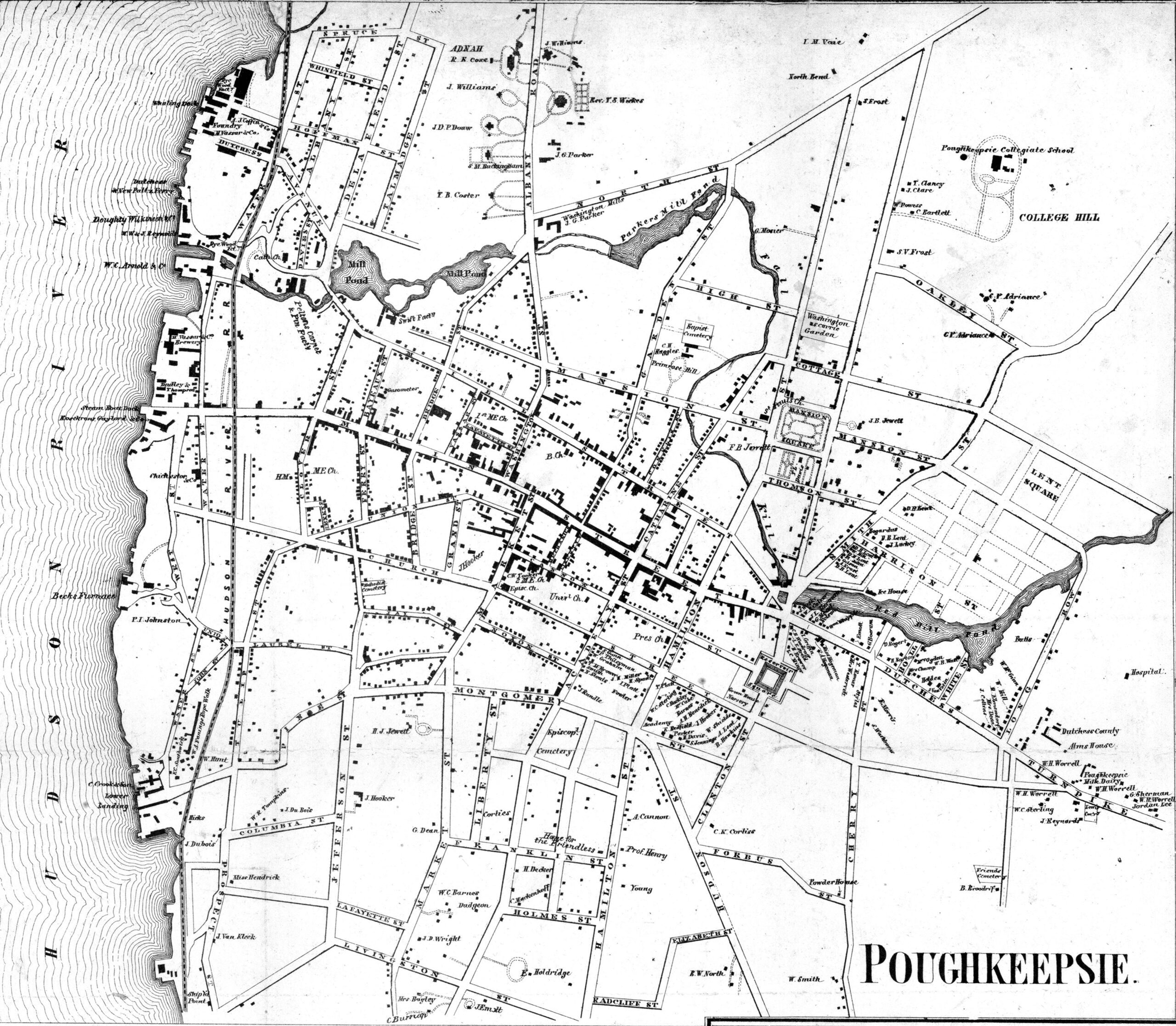
The next map of Poughkeepsie, drafted in 1858, presented an issue. The stumbling block was that in the approximate location where the Vassar home was on the previous map, there were now two residences, neither corresponding exactly to the position of the Vassar residence, although the southernmost structure labeled T.B. Coster more closely resembled the Vassar home’s layout. The other residence in question, a little to the north of the first, was labeled S. M. Buckingham.

Gillette, “Poughkeepsie”, 1858, Dutchess County Historical society, https://dchsny.org/wp-content/uploads/2023/01/1858-Poughkeepsie-Gillette-Map-inset.jpg. Accessed 14 October 2025.
Luckily, the next map I was able to locate was a panoramic map of Poughkeepsie circa 1874. This perspective allowed me to identify the structure on the right (southernmost on the 1858 map) as most similar to the original residence labeled Vassar, due to its central form flanked by two roughly equal wings. Furthermore, through these characteristics and the distinctive pitched front gable end roof, the Coster home is also identifiable as the structure that currently sits just off Washington Street.

Bailey, H. H., “Poughkeepsie N.Y. Aerial View”, 1874, Library of Congress, https://www.loc.gov/resource/g3804p.pm006211/?r=0.079,0.078,0.386,0.186,0. Accessed 14 October 2025.
Affirming that the residence on the right (T. B. Coster house on the 1858 map) is in fact the Vassar property is the resemblance of the residence on the left to known photographs of the Saltford Flower Shop.

Newbie56, “Poughkeepsie NY - SALTFORD FLOWER SHOP GREENHOUSES - Postcard”, 1907, ebay, https://www.ebay.com/itm/354110251129. Accessed 14 October 2025.
This is still further corroborated by the fact that William Saltford, who was once head gardener on the estate of one Steven Madison Buckingham, is known to have engaged in a rent-to-own scheme for said estate sometime between 1876 and 1881 in an effort to expand his violet-growing enterprise.
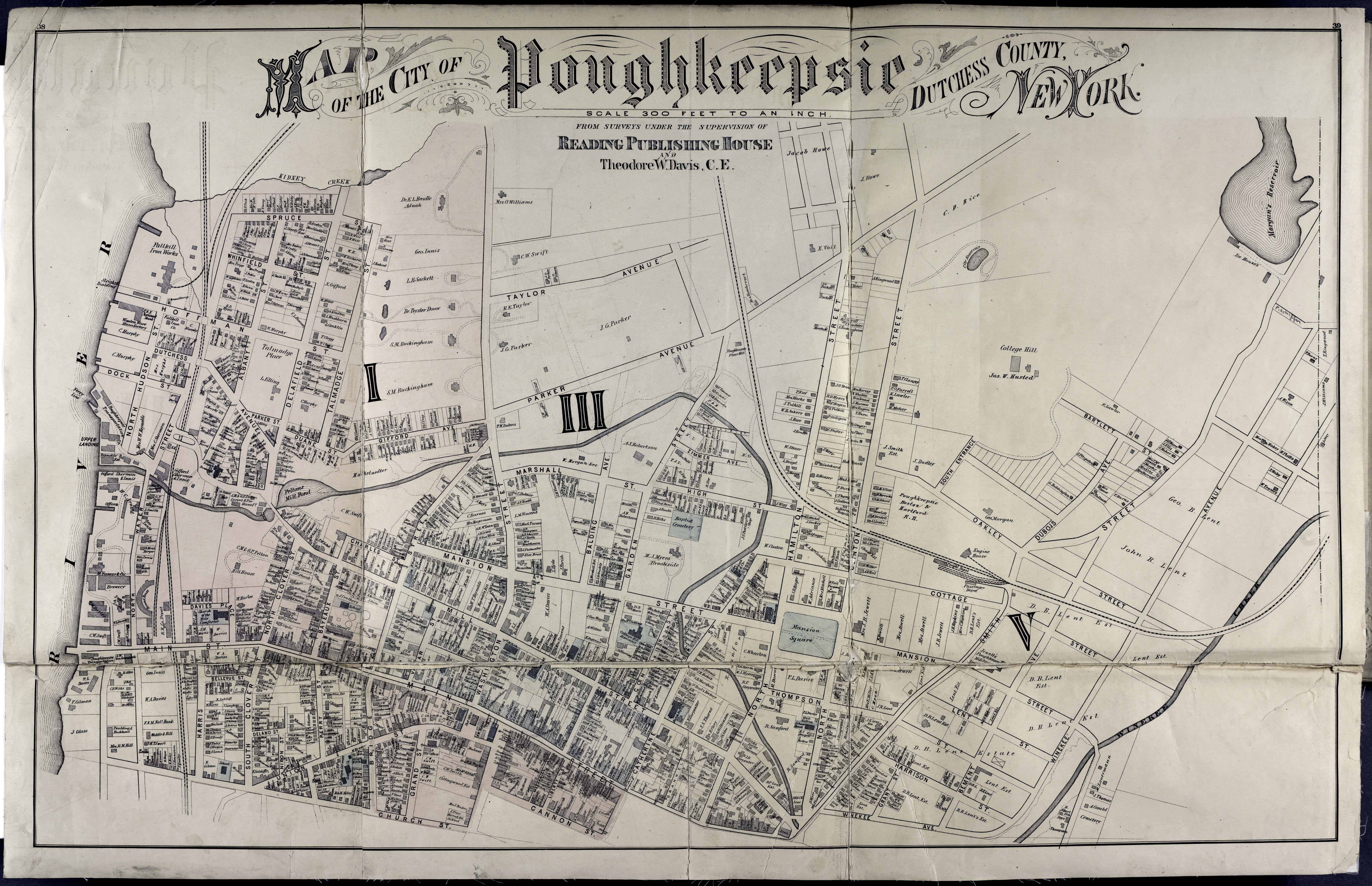
A 1876 map shows S.M. Buckingham to have also acquired the suspected Vassar property. It also shows said property in relation to the homes on Gifford Ave, affirming that the second Buckingham property is the present-day residence just off Washington St.

Davis, Theodore W., “Map of the City of Poughkeepsie”, 1876, Dutchess County Historical Society, https://dchsny.org/wp-content/uploads/2020/02/Pough-1876-Gray-Davis-001.jpg. Accessed 14 October 2025.
Finally, two Sanborn Fire Insurance maps confirm my identification of the two S.M. Buckingham properties. An interesting aside is that Stephen Buckingham was one of Vassar College’s earliest trustees. The 1913 Sanborne map indeed labels the northern Buckingham property as the “W. G. Saltford Green houses” and shows the southern Buckingham property in the same position relative to the walkway over the Hudson (then the Poughkeepsie–Highland Railroad Bridge) that it is today.

Sanborn Map Company, “Sanborn Fire Insurance Map from Poughkeepsie”, 1913, Library of Congress, https://www.loc.gov/resource/g3804pm.g3804pm_g061921913/?sp=10&st=image&r=0.31,0.665,0.903,0.442,0. Accessed 14 October 2025.
An updated version of the same map from 1950 shows the Saltford Green houses have been demolished and the lot subdivided, while the southern S.M. Buckingham residence, which I can now confidently identify as the Vassar home, still stands. I believe the slight discrepancy in the positioning of the structure’s wings between the 1834 and 1858 maps can be attributed to whether the surveyor was viewing the residence from the front or the back, as from whatever side one viewed the home, the wings would appear flush with the opposite facade.

Sanborn Map Company, “Sanborn Fire Insurance Map from Poughkeepsie”, 1913-1950, Library of Congress, https://www.loc.gov/resource/g3804pm.g3804pm_g061921950/?sp=12&st=image&r=0.111,0.614,1.288,0.631,0. Accessed 14 October 2025.
Then came the question of which Vassar did this property belong to? Mathew Vassar’s father, James, was known to have sold the original Vassar homestead on Wappinger Creek in 1801 to start his brewery in the center of the city, eliminating it as a possibility. Mathew’s residences were well documented during the period in question, and his brother John Guy had been dead for two decades by the time the 1834 map was composed. Further, the sale of the property sometime before 1854 did not closely align with the life events or deaths of any of Mathew’s other brothers, and all of his nephews would have been rather young to own property in 1834.
However, after the brewery of Mathew’s father, James, burned in 1811 and Matthew’s brother, John Guy, suffocated to death from the subsequent fumes during salvage efforts, James Vassar is recorded as retiring in reduced financial circumstances to a farm just north of downtown Poughkeepsie. He remained there for the next thirty years. Digging a little deep, I found a history of Vassar College and its founder published in 1867, which cited James’s farm as on the Albany post road (now Washington St), a little north of Fall Kill, where S.M. Buckingham now resides. This not only aligns perfectly with the location of the present-day property in question, but also its ownership, as we know from the 1874 map, S.M. Buckingham owned the property around this time.
As the James Vassar house, this home is not only important in the Vassar lineage but also in the growth of M. Vassar & Co. and the founding of Vassar College. Namely, by 1812, James Vassar was recorded as growing barley on fourteen acres, which once surrounded the home to supply his son’s Brewery, built upon the ruins of his own enterprise. Ultimately, it was that business which provided Matthew Vassar with the wealth to fund Vassar College.
